|
During
the Pennsylvanian Geological period, from 325 to 285 million
years ago, Illinois was a vastly different place that what
we see today. The
Great Lakes,
the
gently rolling prairies,
and the Mississippi, Missouri and Ohio Rivers that we are
so familiar with, did not exist until the end Ice Age, less
than 20,000 years ago.
 During
the Ice Ages the Illinois Glaciation from 500,000 years
ago to 125,000 years ago, covered over 9 million square
miles, from New
York City
westward to St. Louis and Seattle, as well as nearly all
of Canada. Glaciers spread southward into the Midwest from
two centers of ice accumulation in western and eastern Canada.
At it's maximum it reached the northern slopes of the Shawnee
Hills deep in southern Illinois. This huge glacier sloped
upward towards the north, and 75 miles from it's leading
edge the glacier was over a mile thick. Farther up the slope
the glacier was as much as 2 miles thick. As
the glaciers advance they grind and pulverized the earth
below them, and when they retreated the uncovered surface
was blanketed by as much as 300 feet of wind blown soil
that was left behind. During
the Ice Ages the Illinois Glaciation from 500,000 years
ago to 125,000 years ago, covered over 9 million square
miles, from New
York City
westward to St. Louis and Seattle, as well as nearly all
of Canada. Glaciers spread southward into the Midwest from
two centers of ice accumulation in western and eastern Canada.
At it's maximum it reached the northern slopes of the Shawnee
Hills deep in southern Illinois. This huge glacier sloped
upward towards the north, and 75 miles from it's leading
edge the glacier was over a mile thick. Farther up the slope
the glacier was as much as 2 miles thick. As
the glaciers advance they grind and pulverized the earth
below them, and when they retreated the uncovered surface
was blanketed by as much as 300 feet of wind blown soil
that was left behind.
The
great rivers, the Missouri, Mississippi, Ohio and Illinois
did not reach their current course until relatively recently.
( See Glacial Diversion of the Mississippi
River. )
To
put this into a historical perspective, the great lakes,
which hold one-fifth of the fresh water on the earth's surface,
did not reach their current shape and size until 9,000 years
ago, about the time the ancient city of Jericho was founded.
Also, the water level of the lakes did not stabilize at
the current level until approximately 2,500 years ago, about
the time that Pericles began construction of the Parthenon
on the Acropolis in Athens Greece.
THE
PENNSYLVANIAN LANDSCAPE

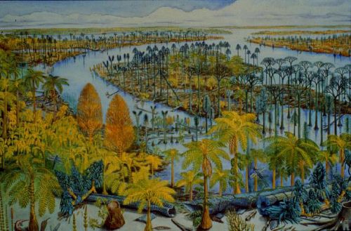
The
land forms that we are so familiar with are a modern replacement
for a terrain that, during the Pennsylvanian period, was
a cross between the bayous of southern Louisiana and the
rain forests of Central and South America, similar to the
drawing to the above. At one time or another during
the Pennsylvanian Period almost all of Illinois was
underwater. The area where the coal was formed was a vast
swamp along the edge of a huge inland sea called the Chicago
Sea, that stretched
from Ohio to the west coast of North America.
 The
land was more heavily forested than in the drawing above,
and were probably quite similar to some of the swamps in
the Cache River Natural Area, in Johnson and Polaski Counties
in extreme Southern Illinois. The
land was more heavily forested than in the drawing above,
and were probably quite similar to some of the swamps in
the Cache River Natural Area, in Johnson and Polaski Counties
in extreme Southern Illinois.
During
this time Illinois was located approximately 20 degrees
south of the equator, with the year around tropical environment
that accompanied the location. There was no seasonal
variation so trees and vegetation grew continuously pilling
up tremendous amounts of leaves and plant material that
turned into peat and then eventually into the coal we mine.
The types of plants that existed at the time were very different
from that we have today, but two insects that we would recognize
have been found as fossils. The earliest know cockroaches
come from this time period, and giant dragonflies with 30"
wingspans.
Below
is a picture of a Pennsylvanian Period, coal forming swamp
reconstructed as a living Biome. This
period is famous for its vast coal swamps, such as the one
depicted here. Such swamps produced the coal from which
the term "Carboniferous", or "carbon bearing" comes from.

Image
from the Field Museum of Natural Nistory. Text from
A View of the Past, An Introduction to Illinois Geology,
Christopher J. Schuberth, Illinois State Museum.
| The
numbers on the illustration above show the following
Plants and animals: |
1.
Lepidodendron tree
2. Sigillaria tree
3. Neuropteris fern
|
4.
Sphenophyllum plant
5. Calamites Tree
6. Cordaites tre
7.
Annularia leaves
|
In
addition, this diorama also shows 2 insects. Just above
the number "2" on the left tree you will find
a giant cockroach, and if you look very carefully
between the rightmost tree marked "2" and to the
right tree (# 5) you will see a giant dragonfly.
|


