|
The National Coal Museum
THE SHOWPLACE OF THE COAL INDUSTRYP.O. Box 369 West Frankfort, Illinois, 62896
618-YES-COAL / yescoal@midwest.net
|
"A Mine of Information!"
The National Coal MuseumTHE SHOWPLACE OF THE COAL INDUSTRYP.O. Box 369 West Frankfort, Illinois, 62896 618-YES-COAL / yescoal@midwest.net |
COAL GEOLOGYWritten by: W. John Nelson
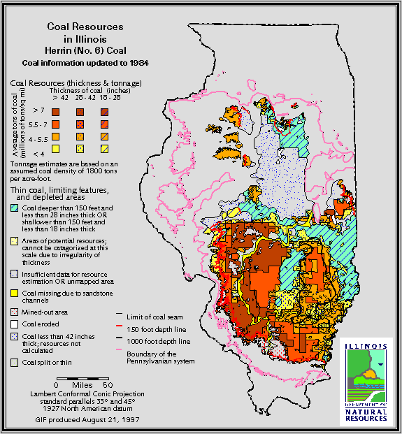
ORIGIN OF COAL The geologic story of Mine 25 began about 310 million years ago, during a time known as the Pennsylvanian Period. The landscape and climate of southern Illinois during the Pennsylvanian differed greatly from those of today. At this time Illinois was part of a vast system of deltas that bordered a shallow sea, and the climate was tropical. Lush forests flourished in the lowlands and swamps along the delta. The trees that grew in Pennsylvanian swamps of Illinois were strange to behold. Giant relatives of today's club mosses, horsetails or scouring rushes, and ferns prevailed. Some of these grew to heights of over 100 feet and had trunks three to four feet in diameter. All were adapted for growth in ever-wet ground and standing water, much like cypress and mangrove trees of today. As plants died, their remains accumulated under water. In the highly acid swamp water, decay was slow. Gradually thick layers of peat developed. All this time the land was slowly sinking, much as the Mississippi delta is sinking today. (New Orleans is largely below sea level and is protected by manmade levees.) This subsidence allowed very thick layers of peat to develop, in some cases 50 feet or greater. At some point (probably triggered by a rise of sea level) the water became too deep to support plant growth, and the swamp was drowned. Peat deposits were buried under layers of mud, silt, sand and limy sediment from rivers and the ocean. The process was repeated many times over a period of several million years, resulting in several dozen peat layers sandwiched by other sediments. Eventually the peat layers were covered by several thousand feet of overburden. The enormous weight of this mass, combined with heat from within the earth, compressed and changed the peat. Water was driven out, and the material became darker and more dense. Gradually it was transformed to coal - first to lignite, then sub- bituminous, and finally bituminous. The layers of mud, sand and limy sediment that enclose the coal beds became shale, sandstone and limestone. It is estimated that 35 to 70 feet of peat were required to make the 7-foot seam of Herrin (No. 6) Coal at Mine 25. Later in geologic history, the area of Illinois was uplifted. Water, wind and glacial ice eroded much of the rock overlying the coal beds. Earth movements tilted the coal beds, and in places broke (faulted) them. As a result, the depth of the coal changes from place to place. Thus, the Herrin (No. 6) Coal crops out at the surface, and has been strip-mined South of Mine 25 near Harrisburg, Marion and Carbondale. The coal declines or dips toward the North, taking it to a depth of 600 feet at Mine 25. This is about 180 feet below sea level. The coal continues to drop toward the North and East, reaching a maximum depth of 708 feet below sea level in Jasper County, Illinois about 80 miles Northeast of Mine 25. COAL SEAM NAMES AND NUMBERS Coal seams in Illinois and other states have both names and numbers. The coal bed at Mine 25 is known as the Herrin (No. 6) Coal. The numbers date back to Amos Worthen, the first State Geologist of Illinois, who mapped the coal deposits of the state during the 1860's. Worthen numbered the coal seams, with No. 1 being oldest or deepest. Originally, only seven coal seams were known. With further mapping and drilling, more were discovered, upsetting the numbering system. Geologists then began naming coal beds for places where they were mined or exposed at the surface. The city of Herrin, about 12 miles West of Mine 25, thus gave its name to the No. 6 Coal. Coal miners and coal companies continue to call the most important coal seams by number as well as by name. Numbers and names of coal beds differ from one state to another. The No. 6 Coal in Illinois is called the No. 11 Coal in western Kentucky, the Mystic Coal in Iowa and the Lexington Coal in Missouri. The Old Ben Coal Company was founded here in Franklin County, and like the county, took its name from Benjamin Franklin.
GEOLOGIC FEATURES AT MINE 25 Floor - The floor in most parts of the mine is claystone, commonly called underclay or fire clay. (The term fire clay refers to a clay that can be fired, or baked, for making bricks and ceramics. Much underclay in Illinois formerly was mined for this purpose.) Underclay commonly contains fossil roots of the plants that formed the coal. Therefore, the underclay was the soil in which the coal-forming vegetation grew. The Blue Band - The "blue band" is a layer of mudstone or shale that occurs in the lower part of the Herrin (No. 6) Coal. The blue band is normally 1 to 3 inches thick and occurs 1 to 3 feet above the base of the coal seam. It sometimes turns bluish gray as it weathers in the mine air, and this is probably the source of the name. Its most remarkable feature is its lateral extent. The blue band occurs almost everywhere the Herrin Coal has been mined in Illinois and western Kentucky. It also occurs in Missouri in the Lexington Coal, which is equivalent to the Herrin. The Herrin Coal contains several other shale and pyrite partings in addition to the blue band. Some of these other partings are traceable across areas of several counties, but none are as widespread as the blue band. Some geologists suggested that the blue band is a volcanic ash deposit. Some coal beds in other areas, such as Germany, Scotland and the western U.S., contain volcanic ash layers. Studies of the mineralogy and chemistry of the blue band, however, indicate that it is an ordinary water-laid clay deposit and not of volcanic origin. Moreover, there is no evidence for volcanic activity in or near Illinois while the Herrin Coal was forming. One theory is that the blue band is sediment deposited in the peat swamp during a major flood. Geologists from the Illinois State Geological Survey have observed that the blue band locally thickens to more than a foot near the Walshville channel. The Walshville channel is the course of an ancient river that existed while the Herrin peat was forming. the channel passes through western Franklin County, about 15 miles west of Mine 25. A thicker blue band near the channel suggests that this was the source of the sediment. Another theory is that the blue band was sediment deposited during a brief rise of sea level that drowned the peat- forming vegetation. A bit of evidence in support of this idea is a fossil identified as Aviculopecten found in a core through the blue band near Henderson, Kentucky. Aviculopecten is a relative of modern scallops, which live mainly in bays where the water is brackish (mixed salt and fresh water). A sea-level rise would bring brackish water into the peat swamp, whereas a river flood would bring in fresh water where scallops presumably would not live. While the Herrin peat was forming in Illinois, glacial ice ages occurred in the cold regions of the earth. The formation and melting of glaciers may have caused sea level to fluctuate, much as it did during the Pleistocene ice ages of the more recent geologic past. Roof - Three types of roof rock are present in mine 25 and can be seen by the public on the guided tour. A gray, silty shale called the Energy Shale forms the immediate roof in most of the mine. The Energy Shale varies from 0 to more than 15 feet thick. It is a weakly laminated shale that contains bands and nodules of reddish-brown siderite. The siderite nodules are similar to those found in gray shale along Mazon Creek in northern Illinois. The Mazon Creek area is famous for fossils of soft-bodied organisms that occur in the siderite nodules. Similar fossils have been reported in the Energy Shale, but not from Mine 25. A black, fissile shale (commonly called "slate" by miners) overlies the Energy Shale. The black shale is called the Anna Shale, after a town in eastern Kansas. The Anna Shale is a few inches to 4 feet thick, and it forms the immediate roof in areas of the mine where the Energy Shale is absent. Anna Shale can be seen along the entry immediately East of the man and materials shaft. The Anna Shale is less affected by moisture than the Energy Shale, and seldom produces roof falls. The third and highest roof-rock unit is the Brereton Limestone, names for a village in Fulton County, western Illinois. The Brereton is a strong rock that makes excellent roof. Unfortunately, it is close to the coal only in small areas of the mine. The Brereton Limestone can be seen above the Anna Shale at the bottom of the man-and-materials shaft. Concretions - Concretions (also called sulphur balls and kettlebottoms) are large balls of hard rock found within the Anna Shale. They are composed primarily of calcite or dolomite, and commonly have a rim of pyrite. Concretions formed by chemical growth around a nucleus while the Anna Shale was still soft sediment. Concretions can be seen in the Anna Shale just South of the cage landing. Concretions are a hazard to miners, because they may fall out of the roof unexpectedly. They are either taken down prior to roof bolting, or supported by a timber or a header board. Bolting through a concretion is dangerous, because the drill may shake it out of the roof. When concretions are taken out of the mine, the pyrite oxidizes in the humid air. The pyrite changes to a white or yellow powder, and the concretions fall apart. (The ones in The Company Store have been shellacked.) The term "kettlebottom" also refers to fossil tree stumps found on the immediate roof of a coal seam. Fossil stumps occur in the Energy Shale in some mines in southern Illinois, but have not been found at Mine 25. Like concretions, fossil stumps are a hazard to miners. They are handled similar to concretions. Coal balls - Coal balls are concretions found within a coal seam. They may be composed of calcite, dolomite, or silica; but most of them are pyrite. Like concretions in the Anna Shale, coal balls formed by mineral precipitation before the peat hardened into coal. Some coal balls contain perfectly preserved plant material, which may be studied by cutting and polishing the coal balls. At Mine 25 coal balls are uncommon. A few small (less than a foot in diameter) pyrite nodules occur near the top of the coal. However, other mines in Franklin county encountered huge masses of coal balls that replaced the entire height of the coal seam. In some cases, the miners had to drill and blast to get through masses of coal balls, adding greatly to the cost of mining. Faults and slips - Coal miners use the term "fault" for many types of features that interrupt a coal bed or the roof. Geologists use the term more specifically for a fracture along which the coal and rock layers are offset. Some mines in southern Illinois encountered large faults, which seriously impacted mining plans. No large faults were encountered at Mine 25. A "slip" is a small fault in the roof or coal. The slip surface is polished and grooved; the grooves are called slickensides. Slips are common in all coal mines; several can be seen on the tour. They are one of the most common causes of roof failure. Rolls - Another type of geologic irregularity at Mine 25 is commonly called a roll. A roll is a protrusion of the roof shale downward into the upper part of the coal. Rolls may be several feet deep, 5 to 20 feet wide, and trace hundreds of feet along their length. Although rolls at Mine 25 occur under both Anna Shale and Energy Shale, the rolls are always filled with the gray Energy shale. An example of a roll is shown on the tour. Rolls interfere with mining the coal, and commonly lead to roof falls. The shale that makes up the roll usually is broken by numerous "slips", which allow large masses of rock to drop out of the roof. Rolls at Mine 25 clearly formed while the peat was soft, before it turned to coal. Most likely, they originated as small channels (probably tidal channels) that eroded part of the peat; the channels subsequently were filled with gray mud. Some rolls may have formed due to uneven slumping or loading of sediment onto the peat while it was being buried. The Herrin (No. 6 ) Coal and its floor and roof are sedimentary rocks, The products of natural processes that acted over millions of years. Geologic features determine how and where coal can be mined. An understanding of geology therefore provides the basis for a successful coal industry.
-- Research provided by: W. John Nelson |
| W. John Nelson
A Founder, Board Member and The Executive Vice President
of The National Coal Museum W. John Nelson has a B. S. and M. S. in Geology.
He has worked at the Illinois State Geological Survey since 1974. Nelson
was in the Coal Section from 1974 through 1988, and conducted extensive
geologic mapping in underground coal mines throughout the state. In 1995
he mapped the geology of the accessible portion of Mine 25.
Nelson met Dr. Ledvina in 1972 while he was a Geology student and
they conducted field work together in Nevada for thesis projects. When
Nelson joined the ISGS in 1974, they were office mates, and they worked
together in a project mapping geology in underground mines and relating
roof failure to geologic causes. They have remained close friends since,
so it was natural for Nelson to become involved with The National Coal
Museum. Although he no longer maps in coal mines on a regular basis,
he maintains an active research interest in coal geology of the Illinois
Basin. W. John Nelson is available to conduct special tours for geology
classes and other groups interested in geology.
|